Echigo Country Trail 63km Course Introduction【Part 2】
Thank you for waiting!
In this article, we introduce the second half of the 63 km course, from Aid Station 2 to the finish line.
Mid-Section of the Course(MAP2)
After passing AS1, the course soon reaches a ridgeline that marks the border between Ojiya City and Oguni Town. This section offers beautiful scenery and wide-open views, but the terrain is more challenging than it looks. The trail includes frequent ups and downs, as well as a narrow ridge known as “Uma-no-Se” (Horseback Ridge), where runners must stay focused.
From here,the course repeatedly climbs and descends between ridges and valleys:
Ridge → descend to AS2 (Ojiya) → climb back to the ridge → descend to AS3 (Ojiya) → return to the ridge again before descending into Oguni Town.
Although not extremely steep, this continuous up-and-down terrain gradually wears down the legs.
At AS2 (Tokimizu), runners can refresh themselves with the famous natural spring water “Baba Shimizu.”
At AS3 (Hakusan Sports Park), a spacious aid station surrounded by open grass fields provides a great place to recover and recharge.
From AS3, the course climbs again over Kirisawa Pass before descending back into Oguni. In the Kirisawa village, local residents warmly cheer for runners, giving them the encouragement needed to push on toward AS4 (Seseragi Park).
After AS4, the course gradually enters the mountains on the western side of the Oguni Basin.

Final Section: The Last Boss – Mt. Hachikoku (MAP3)
The trail continues with repeated climbs and descents as runners gradually gain elevation. Eventually they reach AS5 (Old Hachikoku Steak House) — the entrance to the climb up Mt. Hachikoku, often called the “last boss” of the race.
By this point, runners have covered about 49 km. Only 14 km remain, but the real challenge begins here.
The climb up Mt. Hachikoku is steep overall. In the most difficult sections, ropes are installed to assist runners (yes, there are several!). The climb seems endless — truly the last boss of the course.
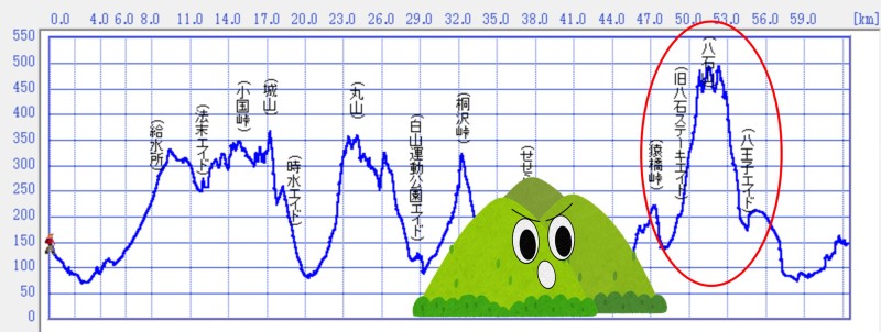
The descent from Mt. Hachikoku is somewhat gentler. After coming down the mountain, runners reach AS6 (Hachioji) in the first village below.
Although the distance between AS5 and AS6 is only 5.5 km, this is often the most exhausting section of the race.
After passing AS6, only 8 km remain. The course crosses the Oguni Basin, where runners are once again encouraged by local residents before heading to the finish at Oguni Forest Park.
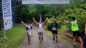
A long day on the trail concludes with a warm and memorable Echigo Country Trail finale.

The 63 km course offers a unique experience of satoyama landscapes, ridgeline trails, rural villages, and heartfelt local support. We hope you enjoy running through the nature and hospitality of Echigo.
Registration for Echigo Country Trail is now open.
We look forward to welcoming runners from around the world!
Echigo Country Trail is a trail running race held in Nagaoka City, Niigata, Japan.